Wildfire is a natural part of Utah’s ecosystems, but the development within and around wildlands over the last two decades has posed challenges for wildfire and safety officials. In 2001, Utah initially identified almost 600 communities and their surrounding natural resources as “at risk” from wildland fire. Our 2025 re-evaluation and update showed that the list for Utah has grown to over 700 communities at risk.
During the evaluation process, communities throughout Utah that are at risk from wildfire are determined by professional wildland fire officials using the standard methodology linked below. Multiple risk factors are analyzed for each community such as: wildfire occurrence, structure susceptibility, local vegetation conditions, infrastructure, and firefighting capabilities.
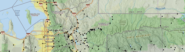
In addition to being required by federal Wildland-Urban Interface grant programs, Utah’s Communities at Risk (CARs) map serves as a tool to prioritize treatments in areas and communities at the highest risk of catastrophic wildfires. Communities considered “at risk” from wildfire can be found on the linked map below.
Please contact one of our local Forestry, Fire, and State Lands Area Offices or the State Office for more information on this or with questions regarding mitigation efforts.
Disclaimer: 1) Point placements for communities are arbitrary and do not necessarily reflect the geographic center of the community. 2) The CARs determination is a generalized, ground-truthed, community evaluation based on the established methodology provided on this site. 3) This map should not be compared to other wildfire risk layers or independently developed parcel or community-level evaluations, as the metrics for determining those risks differ from the methodologies used here.